Mapping the homes of the Skipton prisoners
This blog post is the work of summer intern Joe Everitt, who has been mapping the home addresses of the Skipton prisoners.
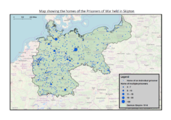
Alongside exploring the injuries and illnesses suffered by the prisoners from Skipton camp, my fellow intern Alice and I have also spent time researching where the prisoners lived. Using records of the inmates’ home addresses, it has been possible to map the homes of the prisoners who spent time in Skipton.
All but six of the 916 inmates lived within Germany’s 1914 borders. The state of Bavaria and Prussian provinces of Brandenburg and the Rhine were home to the greatest number of Skipton prisoners – containing 79, 106 and 81 respectively – while the North-East of Germany was the most sparsely populated region. Seventy of the prisoners lived in the built-up region surrounding Berlin, and Hamburg was the city with the second highest number of homes (26). Of those prisoners that did not live within Germany, five were from Switzerland and one was from Poland. Plotted on Map 1 is the home of every prisoner known to have entered Skipton camp.
By visualising where the prisoners came from through the production of these maps, we have been able to get one step closer to the lives of the inmates from Skipton camp. For example, mapping the prisoners’ homes has made it possible to gain a greater understanding of how events such as the signing of the Treaty of Versailles impacted the prisoners. One of the most controversial aspects of the Treaty was the territorial settlement which saw Germany lose 13% of her land area and 12% of her population.[1] In map 2, Germany’s borders after the territorial settlement came into effect are shown in green and the areas that were taken from Germany are shown in blue.
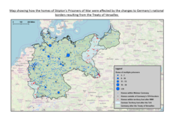
The prisoners from Skipton were repatriated in October 1919, nearly five months after the Treaty of Versailles was signed. Therefore, they were aware of the territories to be ceded by Germany as well as those awaiting a plebiscite to determine their fate. In total, 68 of the men who were held in Skipton lived in territory that was either ceded by Germany or voted to leave and join neighbouring countries. On Map 2, the homes of these men are shown in red. Not only did these men return home as defeated soldiers, but they also faced the indignity of being separated from the country they had lived in and fought for during the war. A further 16 prisoners lived in East Prussia (the most north-eastern part of Germany which was separated from mainland Germany by the Polish Corridor) meaning they had to cross Polish territory to reach the rest of Germany. The territorial changes Germany experienced meant that for these men, simply returning home forced them to confront the consequences of Germany’s defeat.
Like the research we have conducted into the injuries suffered by many of the prisoners at Skipton camp, Map 2 is a reminder that the impact of the war lasted long after the armistice of November 1918. This is just one way that we hope our research has contributed to the fascinating insight that Kriegsgefangen in Skipton has provided into the experiences, thoughts and feelings of the individuals who spent time at the camp.
[1] Martin Gilbert, The Routledge atlas of the First World War (London: Routledge, 2008), p. 144.